
Asset Image Analytics
Image analytics for asset management
Transforming images into insights
Images from drones, fixed cameras, LiDAR, satellites, and other sources provide a powerful view of infrastructure, but their value extends beyond inspection. When combined with AI, operational data, and enterprise workflows, image analytics can identify anomalies, assess asset conditions, support sustainability initiatives, prioritize maintenance, and improve field operations.
Logic20/20 designs and implements end-to-end asset image analytics programs that become part of your daily operations. AI-generated insights automatically create work orders, prioritize inspections, route issues to the appropriate teams, and provide field crews with the information they need to act. By connecting image analytics with asset management, GIS, work management, and other enterprise systems, organizations can automate workflows and make faster, more informed decisions.
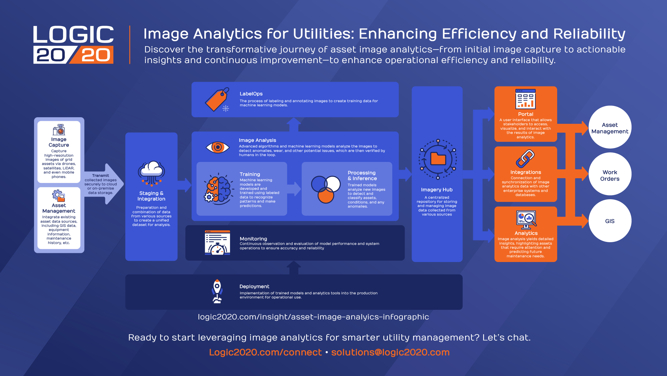
Infographic: The journey of asset image analytics
Image analytics creates value when it's connected to your business. View our infographic to see how image data flows from capture and AI analysis into asset management, work orders, inspections, and field operations.
Use cases: where image analytics makes a difference
A single, integrated image dataset can support multiple business priorities, from inspections and anomaly detection to sustainability initiatives, maintenance planning, and field operations, maximizing the value of every image collected.
Utilities
Vegetation management: AI-powered reviews of drone images rapidly identify high-risk overgrowth to help you prioritize interventions.
Asset management: Evaluate equipment images alongside key inspection, asset, and weather data to enable analytics-driven management.
Risk assessment: Detect and evaluate the impact of hazards such as equipment corrosion or environmental changes.
Proactive & reactive maintenance: Automate analysis of infrastructure images to identify issues and intervene before they escalate.
Disaster recovery: Transform photos of damage into data to prioritize restoration efforts and streamline insurance claim reporting.
Oil & Gas
Leak detection: Use AI-powered image analytics to detect subtle changes in vegetation and surrounding environments that may indicate pipeline leaks, enabling faster investigation and response.
Winterization: Combine weather forecasts, asset data, and image analytics to identify infrastructure at risk from severe winter conditions, prioritize inspections, and schedule field crews before disruptions occur.
Asset integrity management: Analyze images from drones, fixed cameras, and other sources to identify corrosion, equipment degradation, and other indicators of asset health.
Right-of-way monitoring: Analyze aerial, satellite, and drone imagery to detect vegetation encroachment, unauthorized activity, erosion, and other changes that could impact pipeline safety and reliability.
Construction monitoring: Monitor construction progress and site conditions with AI-powered image analytics to verify work completion, identify potential issues early, and improve project oversight.
WEBINAR
See it, solve it: How asset image analytics supercharges utility operations
WHITE PAPER
Transforming utility operations with asset image analytics
Building a strong foundation
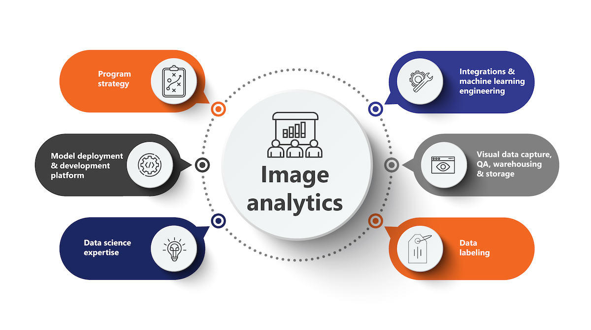
Organizations invest millions capturing images of critical infrastructure. The value isn't in collecting more images. It's in owning the data, models, and workflows that transform those images into operational improvements year after year. Building a strong data foundation ensures image data can be integrated across enterprise systems, support evolving AI models, and drive new operational use cases as your program matures. That's why Logic20/20's approach encompasses six integrated pillars designed to maximize the long-term value of your investment.
Outcomes
Enhanced operational efficiency
Process and analyze vast quantities of visual data at a speed and accuracy level unattainable by human effort, enabling quicker decision making and more streamlined operations.
Improved safety and risk management
Identify potential hazards and maintenance issues—like damaged equipment or overgrown vegetation near critical infrastructure—before they can lead to outages or accidents.
Cost-effective asset management
Automatically generate and prioritize work orders based on asset condition and criticality, helping field teams focus on the highest-value maintenance activities.
Rapid disaster response and recovery
Quickly assess damage from events like storms or wildfires to mobilize recovery efforts more effectively, minimizing downtime and expediting restoration of service.
Streamlined regulatory compliance and reporting
Monitor and document compliance with industry regulations to facilitate reporting while ensuring accuracy.
Improved customer satisfaction
By proactively addressing potential issues and minimizing disruptions, organizations can significantly improve customer satisfaction and create a better overall customer experience.
ACCELERATOR
TreeVision
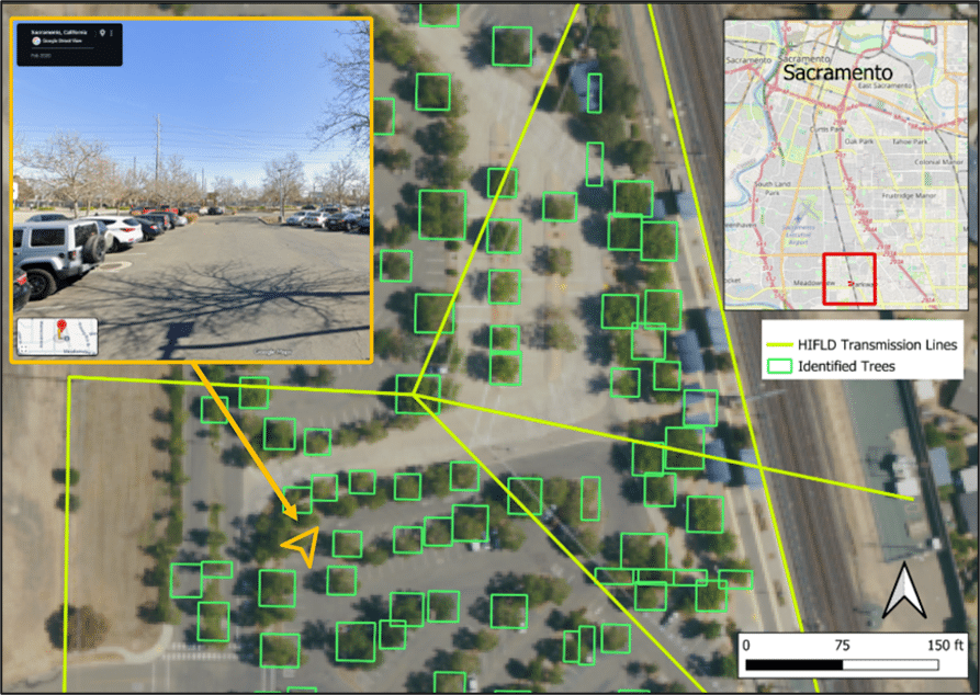
Logic20/20 TreeVision uses publicly available satellite imagery, Microsoft Planetary Computer, and Azure-based geospatial processing to detect individual trees, measure vegetation proximity to utility infrastructure, and generate GIS-ready datasets for downstream platforms and workflows. It’s deployable in as little as seven weeks.
Case studies
At Logic20/20, we help you put your data to work, with outcomes that enable you to achieve your goals.
Featured
Building a business case for asset image analytics
Insights
The missing link between inspection imagery and grid intelligence
Making inspection imagery usable at scale
Drones plus AI: meet the future of utility asset management
What are your challenges? Let's talk through the solutions.